Promoting awareness of the archaeology and history of North Devon
Copyright © 2015 North Devon Archaeological Society
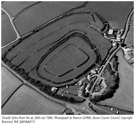
Clovelly Dykes -
I recently spent a Sunday cutting back gorse and clearing bracken at Clovelly Dykes,
the Iron-
In super sunny weather, we had a great day, with picnic and bonfire, and cleared quite a large area of overgrown bushes/gorse, etc.
It occurred to me that NDAS members might like to go and visit the site, (there was in fact an NDAS visit some years ago, I believe), and to this end I contacted the farmer and have arranged for a visit by NDAS members for Sunday 18 June at 2pm.We would meet at East Dyke Farm, to find which take the A39 towards Kilkhampton and Bude, turning right towards Clovelly at the Clovelly roundabout. Just down the road a few yards turn right into the farm yard and park.Wear suitable footwear and clothing. Cressida Whitton from the County Archaeological Service has kindly agreed to be our guide for the afternoon. Please contact me on 01769 572963 if you wish to join in, as the farmer would like to know how many people are likely to turn up!
Surprisingly unknown to many people in North Devon, Clovelly Dykes is perhaps the most impressive prehistoric structure in the area or indeed in the whole of Devon. The earthwork is situated about a mile from Clovelly village right beside the A39, the road to Clovelly village cutting across the east side of the ramparts and segregating part of the original enclosure.
Although generally known as a hillfort, the fact that it is not visible from the
road indicates that this is not an imposing earthwork such as Hembury hillfort in
east Devon and is unlikely to be in any way defensive. The monument, which covers
over 8 hectares, is laid out on a flat site and consists of concentric sub-
No excavation has ever taken place at Clovelly Dykes so there is no direct chronological
evidence, but a comparable site at Milber Down near Newton Abbot was partly excavated
in the 1930s by Aileen Fox and C.A.Raleigh-
south-
Interestingly it was in the area of Clovelly Dykes that H. Eggerton-
impossible to determine at present. The site itself is of course a scheduled ancient monument and permission from English Heritage would be required to do any work in it, but it would be very satisfying to know its true age.
Bibliography:
Fox, A. (1952) Hillslope Forts and related earthworks in South-
Fox, A. (1996) Prehistoric Hillforts in Devon, Devon Books.
Griffith, F. (1988) Devon’s Past: An Aerial View, Devon Books.
Reprinted from the Devonian Year Book, 1927.
Clovelly Dykes. -
AN examination of the Dykes and their neighbourhood in June, 1926, yielded the following results :—
(1) It was noticeable that the inner lines on the west were escarpments, and not the ordinary vallum and fosse.
(2) The inmost enclosure, viewed from the north, was apparently a rectangle, a regular figure. In fact, it was not so, as towards the south the long sides converge.
(3) At exactly one-
The enclosure lay with a south aspect on gently sloping ground. This location was not prescribed by local conditions which would have allowed accommodation to any slope, and was therefore carefully chosen with reference to the compass points and to metaphysical beliefs.
2. Plan and Area.
On the map a variety of points demand attention. The Dykes are not symmetrical on
any line ; the south-
By scaling the 25-
To check the above working, I examined the plans of some of the earthworks catalogued in the Victoria County History.
There were difficulties in working by scale accurately, but the results obtained may be thus tabulated :—
Area of enclosure in sq. A siatic ft.
Farway 6,400
Beacon (Martinhoe) 6,400
Parracombe ... 6,400
Dunterton 6,400
Seaworthy 48,000
Coffinswell 84,000
Shoulsbury (High Bray) 160,000
Castle Dykes (Chudleigh) 240,000
For Old Barrow Camp (Countisbury), with the square inside the circle, we have a more complicated calculation. There the circle is ten times as large as the inmost enclosure, on areas of 48,000 and 4,800 square feet respectively.
Let me say at once that none of my figures were exactly as in the above table. They
must all be checked by re-
3. Water Supply.
There can be little doubt that the water supply for the Dykes was from the springs
at the north-
4. Road Approaches.
It is remarkable that not a single road or lane approaches the Dykes directly from the south. Possibly the Dykes were isolated on that side by bogs ; probably not, as we shall see later that the associated people cultivated upland terraces and would have drained such.
5. Ground Plan.
I have already indicated the difficulties of the map of the Dykes. My solution, giving due weight to the differentiation of scarped wall and ditch is, in brief, that the Dykes were a maze, a labyrinth, to which the approach was by the ditches.
Diagrammatically the plan is as shown on next page :—
At A is the true entrance, the path following the outer ditch ; at B there would
be a stockaded or taboo-
One is not hard pressed to exemplify the suggestions.
Daedalus was long regarded as purely mythical, but the excavations in Crete have done something to rehabilitate a belief in the labyrinth of the Minotaur, nor need we forget that King Prempeh of Kumassi thought himself secare in a mazy stockade. We may also find a reason in this why no road approached from the south, where the outer entrance was located.
6. Purpose.
The orderly lack of symmetry suggests that there was a general purpose behind the
plan. The projection to the southeast indicates that a pointer was required to the
southern tropic, to show when the seasons would be propitious by the sun entering
upon its northern course. The tumulus, some 1,800 Asiatic feet due west of the north-
" Now when he (the Sun) moves northwards, then he is among the Gods, then he guards the Gods ; and when he moves southwards, then he is among the Fathers, then he guards the Fathers. When he (the Sun) moves northwards, then one may set up his fires ; the Gods have the evil dispelled from them (by the Sun) ; he (the sacrificer) therefore dispels the evil from himself; the Gods are immortal; he, therefore, though there is for him no prospect of immortality, attains (the full measure of) life, who sets up his fires during that time." And, conversely, as the Fathers have no power over evil, to set up sacrificial fires during the southward course of the sun is ineffectual in warding off evil and in prolonging life.—(Satapatha Brahmana, II, 1. 3.).
Not only is the quotation, I submit, apt, but a precisely similar case of a pointer to the southern solstice will be found on the great karewa of Yendarhom, a few miles north of Srinagar (Kashmir), where the arc of standing megaliths is one of the great but little known relics of that country.
7. Economics of the Period.
The Dykes are clearly associated with an upland civilisation.
It may be calculated for the purpose of argument that it would have taken one man
working twenty-
In short, the Dykes were a colossal undertaking for early times ; the tribal labour market and food supply must have been dislocated during the period of construction, and no such work could have been undertaken without either the express sanction of the tribal government or the submission of plans and estimates by the tribal priests. In no nomadic state would it have been possible for so great a work to be carried out and we must assume that the Dykes were built by agriculturalists.
We are fortunate in finding on the neighbouring Bursdon and Welsford moors the remains
of an agricultural civilisation. There, in a large shallow basin about a mile square,
we may find lines of ancient terraces for cultivation, tumili on the terraces, a
mystic circle, worked flints on an old village site, ancient trackways linking the
whole. There is, too, if only had the time and money, the possibility of finding
a lake-
These features combine to elevate the imagination and to clear one's vision of a
dim past. The limiting factor of this civilisation around Clovelly was the 500 feet
contour, perhaps the 600 feet contour, and even for that high level there is an area
continuous enough to justify our suggesting that in these moors of Hartland we have
a " little Dartmoor," with a range, of course, extending far beyond the limits I
have mentioned In the accompanying sketch map I have indicated the principal points,
and it need only be added in explanation that the probable village site is the first
field of Summerwell Farm, on the south of the road as one draws off from the bog-
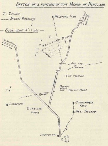
Once ascertained, the terraces are a prominent feature on the hill-
In estimating the reservoir of wealth from which was drawn the capital and labour
involved in the construction of the Dykes, there grows a picture of Hartland and
Clovelly very unlike the present-
8. Summary.
Clovelly Dykes would seem to combine the functions of seasonal clock and holy ground. In other words, it was the cathedral of at least one early race in Devon, the abode perhaps of great priests, a focus of tribal religious life and almost certainly taboo to the rank and file, except perhaps in its outer courts. The eccentricity of the ground plan indicates that the Dykes were not primarily for defensive purposes. Those who have seen the lines of ancestors (vadil) set up at the village temples of Hindu India and have realised their function as genealogical trees (sat pedi) will find no difficulty in the surmise that the long low mound in the inmost enclosure was a rough earthern platform, bearing a line of anthropomorphic stocks and stones (but see para. 9) which served to link Now with Then, the Seen with the Unseen—Man with God.
If the builders (and by builders I mean the master builders, the aristocracy) were
Aryan, having root ideas common with the Indo-
9. The Maha-
We may strengthen the foregoing hypothesis by corroboration from the Satapatha Brahmana
(Sacred Books of the East, Vols. XII, XXVI, XLI, XLIII, XIvIV). This work is a composite
prayer and ritual book of the Indian Indo-
In the ceremonial devoted to the worship of Agni-
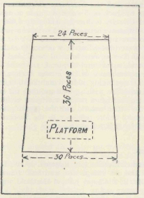
but it was essential that the narrow end should point to the east (not as at Clovelly to the south) to ward off magically the chance of attack by enemies. The dimensions prescribed give a superficial area of 972 square paces.
On the assumption that 6,400 was the mystic number of square feet required for such a place (and where we are working out a problem, we must proceed by trial and error), this gives a value of 6.59 square Asiatic feet to a square pace : Square root of 6.59 = 2.567
If 13.5 standard inches are equivalent to one foot, the length of the pace will be :
2.567 x 13.5 -
You cannot read the Satapalha Brahmana without being impressed by the luck of 5's and 8's and compounds thereof.
The 80,000 of Clovelly is directly related to 6,400 in its factors. The only real
difference between the two cases is in the orientation of the enclosure, but the
point need not be stressed. The Indo-
The builders in Devon were in a cul-
10. Tradition.
An upland civilisation long lingered. After I had found the terraces and the old
village site and had framed the general hypothesis, Mr. Richard Pearse-
" . . . DeanMilles' Parochial Returns, circa 1760, now in the Bodleian. I always thought his informant had been pulling the old man's leg.
Secinton, a large town of former times.
Hendon, a large town also.
Firebeacon, a large town. Of these places nothing remains.
There was a Swannery near Bradstones well.
A great many human bones found in digging the field called Newling.
Bradstone well water good for scurvy.
" Is the reservoir (below Summerwell)
? If so, where is Bradstones Well ? The three places named are the three chief heights around the moor. Secinton is in a direct line between the reservoir and Clovelly Dykes. Hendon is the highest point (765 feet) in line with Woolley Barrows. Firebeacon is the highest point, almost, but not quite, in line with Embury Beacon."
Here, then, is a new stimulus to further local spade work. Bradstones must have been
a bridge of megaliths or a line of stepping-
Bradstones Well may very possibly have been converted to a second swannery pond after
the Reformation, the other being older. The value of the well water as a specific
for scurvy would be due to the presence of bog water. Welsford has always been interpreted
to mean the Welsh-
Newling is possibly Newlands near Woolley Barrows. It may well be argued that ancient
tradition will not be persistent over so long a period. I must record that I found
one tradition in Sind, in the desert beyond Karachi, among Mahommedans, where Hinduism
has been extinct for 1,200 years, regarding a circle of stones around a cromlech,
that the ghosts at midday and at night throw lighted torches at you—a reference to
the ancient fire-
Of course, it is not suggested that the whole of Dean Milles' record relates to prehistoric times, the mention of the swannery being enough to indicate otherwise. It does emphasise, however, that even in the middle ages there were settlements on the hills, settlements now long forgotten, that there was a well at Bradstones of great popular repute (and therefore of antiquity) and it is no striving after a conclusion which gives the deduction of a continuity of life on these high hills.
Mr. Chope has since recovered a hitherto meaningless
doggerel:—
" Yennon (Hendon) was a market town,
When Lunnon was a vuzzy down,"
which, though of a common pattern, must, in the language of the Stock Exchange, mean something or nothing. My submission is that all such traditions carry a meaning, that it was not until the monks preached by practice " laborare est orare " that the highland civilisation really began to give way to the lowland one. Vested interests, of course, remained, though gradually passing away. Thus from the earliest times to one not long gone, through quite forgotten, the hills of Hartland were cultivated by agriculturalists, who had done so continually from the time the Clovelly Dykes were built.