Promoting awareness of the archaeology and history of North Devon

Copyright © 2015 North Devon Archaeological Society

Back

Parracombe Project: Holworthy Farm - Terry Green

(Newsletter No 4 Autumn 2002)


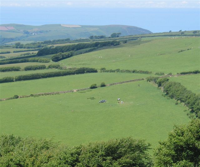
Holworthy Farm, belonging to Phil and Julie Rawle, lies in a combe to the south-east of Parracombe, NGR SS 68-44-.

Since the last newsletter, the Parracombe project has made further progress, in that 
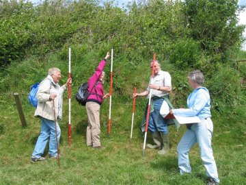
the investigation of Holworthy Farm is now properly under way. On the 19th May, Society members and volunteers from Parracombe met at Holworthy Farm to field-walk the field known as “Truckle Butt” (Fig.1). The field was gridded in 15 metre squares and throughout a chilly, blustery morning the team plodded up and down, heads bent, gaze fixed on the ground. Apart from several kilograms of stone picked up out of eagerness or uncertainty, the resulting collection amounted to roughly fifty items which could be counted artefactual. These ranged from fragments of glass and 19th century pottery to post-medieval North Devon ware and two fragments which have been identified as medieval. There were also a number of flint fragments, some of which appeared to be prehistoric and worked, others to have been introduced recently (it is plausibly suggested, in imported bales of fodder or straw). The field represents two separate fields on the 1840 tithe map, the lower of which (called “Trucklebed” in the tithe apportionment) appears to be an extension to the (probably) medieval field-system. It was in this area that the medieval sherds were found. The upper part of the field is called in the tithe apportionment “Lower Square Close”. Here were post-medieval and early modern materials. Within the land of Holworthy Farm is a slight earthwork (NGR: SS68704433) comprising anovoid enclosure with an associated linear feature running away from it at a tangent (Fig.1 and see the AP on page 72 of The Field Archaeology of Exmoor.)


This site, which is not scheduled, represented an opportunity to investigate by excavation a possibly prehistoric element of the landscape. In order to help with funding, our fund-raiser Richard Beer had successfully applied for money from the Council for British Archaeology to pay for a geophysical survey on the earthwork, which is located in the field known as Greenwell to the north-east of our fieldwalking area. On two days in June, Ross Dean ofSubstratum conducted a resistivity survey of the earthworks and immediate surroundings with encouraging results. The plot confirmed the existence of an oval feature with a possible entrance and what appeared to be a ditch. Interestingly, a group of dowsers, who spent a day on the site, suggested - without prior knowledge - an entrance in more or less the same location.


On 15th July - a very hot day - a team of volunteers gathered to begin a limited excavation (an evaluation) on the enclosure. The excavation lasted six days, during which three trenches were opened up. Trench 1 was placed across the linearfeature, trench 2 across the edge of the enclosure and trench 3 in the area which, it was thought, might represent an entrance. The linear feature turned out to be a spread of stones, almost all of Hangman grit (the local Devonian sandstone), and all showing signs of weathering. At the core of the spread was a more regular structure of large stones which may have represented the revetment of a natural ridge perhaps to form a lynchet. Trench 2 revealed a spread of the same stone, which, when picked apart, seemed to represent the remains of a stone bank about 3 metres in width. There was no sign of a ditch, though there was one post-hole on the “outside” of the bank. Trench 3 cut across the enclosure bank where it exploited the natural ridge. Here the stone-work was more substantial and on the “inside” there was a surface of closely packed small stones which was interpreted as metalling. There was noclear sign of an entrance.


The only datable finds from the three trenches were two sherds of medieval pottery from the topsoil and a small number of flint beach pebbles, some with a preparation flake removed. These might be thought to represent mesolithic activity. On the face of it, the evidence which we recovered leads to no clear conclusions. The huge amount of weathered stone in the structure suggests the result of initial ground clearance ahead of cultivation. The lack of a ditch was unexpected, but as the enclosure appears to be built of stone, like a ring-cairn, rather than earth, there would have been no need to dig one. There seems to be nothing defensive about the structure, either against people or against stock. The couple of medieval sherds suggest that the ground was ploughed in the medieval period, which might explain the bank or lynchet. Without further investigation, no date can be suggested for the enclosure.


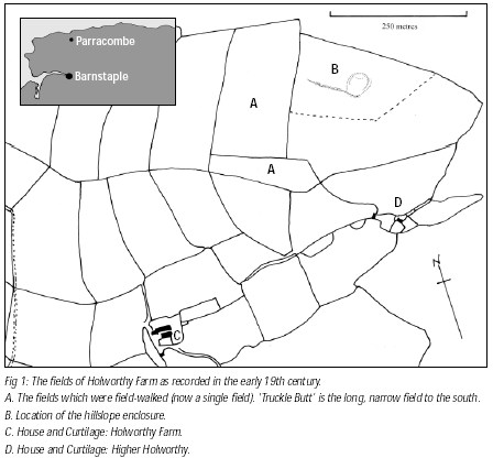
The next step at Holworthy will be to examine the site of Higher Holworthy. This separate holding was listed in the 1840 tithe apportionment, and on the tithe map two buildings are represented together with a garden. On the site now are only the garden enclosure and the ruins of a barn. Of the house there is no obvious sign. It is said that before the 1952 flood there was a pack-horse bridge here, and it may be that the flood water washed away both the bridge and any remnants of a house. For the project it will be a matter of recording what is visible and probably test-pitting. We shall also dig test-pits within the curtilage of Holworthy farmhouse, where Julie Rawle has been picking up postmedieval pottery from the flowerbeds. Finally, during the winter we shall conduct a fieldboundary survey. Volunteers prepared to stomp around with clipboard, pencil and ranging pole are always welcome!


Fieldwork, Summer 2003: (Newsletter No 5 2003)


Parracombe

The first priority this summer is to continue with our investigation of the Parracombe landscape. At Holworthy Farm, where we began work last year, we intend to conclude our survey by recording the field-boundaries and test-pitting at the abandoned site of Higher Holworthy as well as next to the Holworthy farmhouse itself. During last year Dr Ralph Fyfe of Exeter University took cores from a spring-mire within the farm in order to track changes in land-use over time. And later this year, Chris Carey, also of Exeter University, will be taking soil-samples from the area of the hillslope enclosure for geochemical analysis.


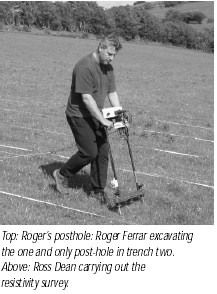
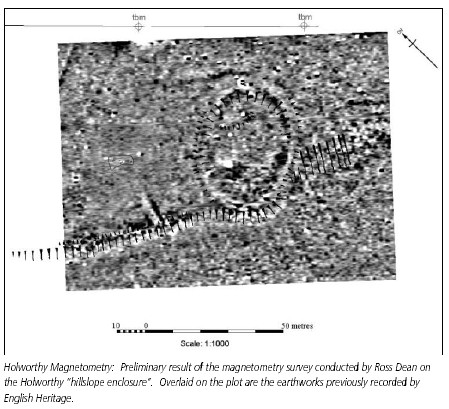
During March Ross Dean conducted a magnetometry survey on the hillslope enclosure with very interesting results. These have encouraged us to plan a further excavation on the enclosure this July. By the end of the year, therefore, we shall have data from a variety of surveys as well as from excavation, which will enable us to begin to understand landscape development on this fringe of the parish.


From Holworthy, we shall move to the other side of the parish to West Middleton Farm. Having previously surveyed the field-boundaries of East Middleton, it makes sense to look at the other half of what was probably a single unit until the mid-15th century, a unit which represents the second largest of the Domesday manors of Parracombe.

This summer, therefore…

The first requirement is to do the field-boundary survey. Since increasing growth of vegetation makes it more difficult, this is now a priority and will take place during May. The weekends of 10th-11th May and 17th-18th May are proposed. Field-boundary survey amounts to a walk in very pleasant surroundings with a clear purpose in mind and clip-board in hand ( a bit like golf, but with a more informative result). The more volunteers we have, the more likely it is that we can complete the boundaries of Holworthy Farm in one weekend, which would mean that on the second weekend we could go on to dig test-pits at the site of Higher Holworthy. As for the ‘hillslope enclosure’, the results of Ross Dean’s recent magnetometry survey encourage us to take a closer look at the features which they suggest.

We propose, therefore, to undertake a further excavation on the enclosure this year. This will take place during July and will last a week. Proposed dates are Monday 14th to Saturday 19th July, but contact Colin (01271 882152) to confirm this. Work at West Middleton will begin in late summer. Phone Colin for details..


Parracombe Project: Holworthy Farm 2003- Terry Green


Field Boundary Survey:

As proposed in the Spring 2003 NDAS Newsletter, a field-boundary survey of Holworthy Farm was undertaken over four days in May. The procedure was the now familiar one of setting out with ranging-poles, hand measuring-tapes, recordsheets and a clipboard to trek from boundary to boundary noting features and taking measurements. The results have been fed into a data-base and although they have not yet been fully processed and transferred to the map, some interesting observations can already be made. For one thing, there is a distinct difference between the boundaries at Holworthy and those recorded at East Middleton, in that Holworthy has a much higher proportion of earth banks without stone facing.


Preparations for the survey

In the 19th century William Smyth described the farm as poor and this may account for the less elaborate treatment of the boundaries. Another clear difference is the presence of a number of corn-ditches. This term, first used by Fleming on Dartmoor, refers to earth banks with a profile like a right-angled triangle. On the side looking away from the cultivated land is a vertical face armed with stock-proof coping ( a jutting course of flat stones near the top) and with a ditch at the base.


On the cultivated side the bank presents a sloping face. The purpose is to discourage animals from straying from the common onto cultivated land, and to make it easy to chase them out if they should somehow get in. A corn-ditch therefore represents the limit of cultivation (or controlled grazing) at the time of its construction, and for our purposes provides a clue to the development of land-use. As at East Middleton, the banks that we might suppose to be earliest are much more bulky than the later ones. In fact one bank near the bottom of the combe is so massive (some 5 metres through the base and 2 metres high!), that on the 1840 tithe map it is shown as a strip of woodland. The reason for its great size is not at all clear and merits investigation.


Excavation:


In the previous newsletter, members will have seen the preliminary results of Ross Deans magnetometry survey of the Holworthy hillslope enclosure. Further tweaking of the image brought into focus features that Ross recommended for close examination. 
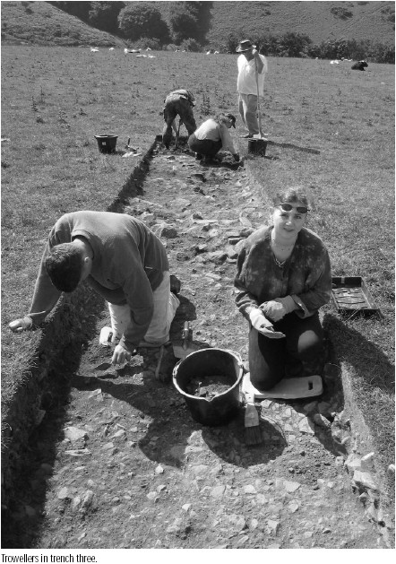
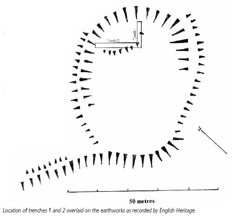
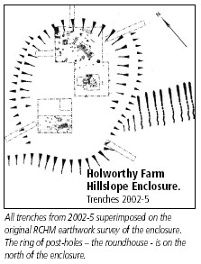
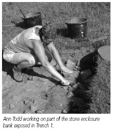
Excavation began on 14th July. With the magnetometry as a guide, two trenches were pegged out, one of 8.5m x 1.5m running north-east to south-west (Trench 1) and one of 15m x 1.5m running north-west to south-east (Trench 2), the two meeting to form an elongated 'L'. On deturfing we encountered the same spread of weathered stone as we had seen in 2002 lying immediately beneath the turf with a greater density of stone towards the circumference of the enclosure. This strengthened the conclusion that the enclosing bank was built of stone collected from the surface and that over the centuries the stones had been spread by ploughing.


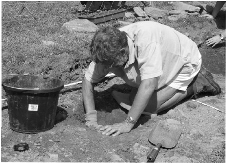
Recording a post hole at Holworthy


In the process of exposing the stone layer in Trench 1, specifically in the area where the two trenches met, a number of flint flakes and small thumbnail scrapers were found. These were the first evidence we had that might point to a prehistoric date. More was soon to come, however. In the central section of Trench 2, the stones lay less densely and plough-soil was initially removed with a mattock.Working in this area, Alistair Miller noticed a soft spot. A probe with a trowel produced half a dozen fragments of thick, crumbly pottery and subsequent careful trowelling showed that we had the largely intact base of a vessel, the feel and fabric of which suggested prehistoric, specifically Bronze Age. The vessel appeared to have been sheared off by the plough, but fragments had not been scattered far. One piece lying somewhat apart was lifted and appeared to be a rim-sherd and potentially identifiable. The rest was left in place and protected under an upturned wheelbarrow.


This exciting discovery came on the second day. On the third day came the rain and the scuppering of any plan to complete the excavation in a week. In the end we spent sixteen days dodging between the spells of rain in the wettest weeks of an otherwise glorious summer! Nevertheless, our small, but reliable team worked on manfully.


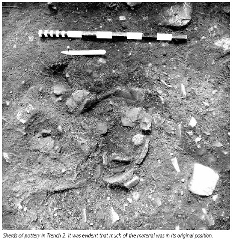
In Trench 2 a broad band of heavy stone was exposed lying at right-angles to the section. At first it appeared that the stones might be lying in a ditch, but a half-section through the feature showed them to lie in a shallow depression. This band of stones seems to correspond to one of Ross’s positive magnetic features and may represent the edge of a platform. In Trench 1, where the spread of the bank was densest, removal of the stones revealed a surface of small, flat stones in a single horizon and beneath them a gravelly layer overlying the orange subsoil. Provisionally we are regarding this as a preserved metalled surface corresponding to that seen in Trench 3 in 2002. In Trench 2 there were further finds of flint scrapers and two post-holes were identified.


After heavy rain had flooded the lower part of the excavation, the area where the two trenches met was suspiciously slow to dry out. This was where we had seen most of the flints and where a number of large stones protruded though the ‘metalled’ surface. Consequently a 1.5 x 1.5 metre excavation was carried out here. Beneath the layer of small flat stones and gravel, a gulley was revealed which was filled with charcoal stained soil. The large stones lay in this gulley, and when they were removed, charcoal, including pieces big enough for species identification, was found beneath them.We cannot be sure, but the gulley, which was about 30 cm wide and 15 cm deep, seemed to show a curvature and may be part of the drip gulley of a round house. Alternatively it may represent a drain. Within the charcoal stained fill was one abraded sherd of BA pottery and one flint flake.


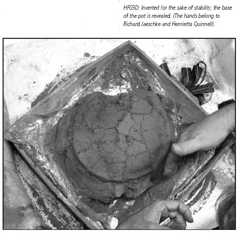
The pottery in trench 2 having been left in place until we were ready for it, the intention was to lift it in a block. Taking advice from professional conservators Richard and Helena Jaeschke, we excavated around the mass down to bed-rock, enclosed it in a box of MDF, strapped it, protected it with cling-film and kitchen-foil, poured in plaster-of-Paris and then, cutting beneath the block with a spade, lifted it onto a metal sheet and transferred it to a baker’s loaf tray (see cover picture). It was taken at once to the Museum of Barnstaple and North Devon whence it was collected by the Jaeschkes, who are now working on it.We are gratified to find that it is in fact the intact base of a vessel now identified by Henrietta Quinnell as Middle Bronze Age Trevisker ware and one of very few found in North Devon or Exmoor.


The Society owes its thanks to all those who helped with the excavation. In particular, lifting the pot was a great success, and I must thank Alistair Miller, Roger Ferrar, Derry Bryant, Janet Daynes and Gordon Fisher for their valuable efforts. Thanks are due also to all who assisted in the dig; once again the co-operation of Phil and Julie Rawle of Holworthy Farm was invaluable.


This year’s excavation had its difficulties, but nevertheless our small, but reliable team gathered enough evidence to raise questions that need to be answered by further excavation in the future.


Field Boundary Survey at Holworthy Farm: The Results - Terry Green (Newsletter No 7 2004)


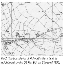
In previous editions of the NDAS Newsletter there have been several references to the fieldboundary survey being conducted within the Parracombe Project. The aim of this activity is to ascertain whether it is possible, through objective analysis of the features of the very prominent hedge-banks, to develop a tool which will help us to unravel the evolution of the Parracombe fieldsystems.


The development of such a tool falls within the research priorities highlighted in the recently formulated “Historic Environment Research Strategy for Exmoor” (Objective 8.i). To date nearly 300 boundaries have been recorded on East Middleton and Holworthy Farms. Now the data collected have been ‘crunched’ and some patterns have emerged. What do they tell us at Holworthy Farm?


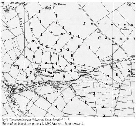
At Holworthy 117 boundaries or boundary segments were recorded. The data recorded for each boundary include width through the base, width across the top, height from the ground on both sides, presence or absence of stone facing, style of facing, shrub and tree species present, evidence of hedge management, topography and relationship to other boundaries, watercourses, trackways or farm buildings. On the basis of the oft repeated remark, “You have to respect the work that went into these boundaries”, it seems obvious that the quantity of material mounded up to make a hedge-bank must in some way reflect its importance and might also reflect a changing perception of land management. Therefore the dimensions have been selected as the parameters most likely to tell us something. Clearly the present dimensions have to be regarded critically.We do not ignore the fact that during their existence the hedge-banks will have been subject to erosion and to some degree of remaking. But where a boundary has been well maintained, it seems probable that the amount of material present now is probably not greatly different from what was first put in place.


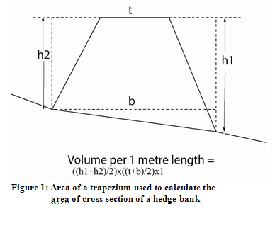
Measuring width at base, width at top and height gives the dimensions of a cross section which is essentially a trapezium the area of which is given by the formula h x (b+t)/2 (where h = height, b = base, t = top). As few hedge-banks are situated on level ground, the height taken on both sides has to be averaged, ie. (h1+h2)/2. To provide a formula that will accommodate the majority of sites, four dimensions should therefore be taken: the height on both sides of the boundary, the width of the base of the boundary taken on a horizontal from the base of the shortest side, and the width across the top of the boundary. From these measurements the following formula (the area of a trapezium x 1) will give you a figure for the volume in cubic metres of a one metre length of the boundary: [(h1+h2)/2 x (b+t)/2] x 1 (see Figure 1). The result will be to a decimal point. This is then rounded to the nearest whole number (up or down) producing the basis of a simple numerical classification: Classes 1,2,3,4,5,6,7, etc based on volume.


If we now apply this numerical classification to a map showing the boundaries of Holworthy Farm, patterns begin to emerge. There are few boundaries which are consistently of one class; what appears to be a single boundary can be a class 3 at some part(s) of its length and a class 4 at others. There is only one instance of a 2 juxtaposed to a 3. There is no example of a boundary being both a 2 and a 1. The 2’s and 1’s are restricted to either the boundaries which postdate the tithe map of 1840; or they are cornditches at the outer limits of the land that was enclosed before 1840. In addition they include one boundary which was present in 1840, but which, for certain reasons, is suspected to be a relatively late addition. The 3’s and 4’s are therefore characteristic of the land which was enclosed before 1840. The number of 5’s, 6’s and 7’s is very small and is restricted to the land closest to the farm buildings. It begins to seem, therefore, that there is a group of slighter boundaries characteristic of recently enclosed land and a group of heavier boundaries associated with older enclosed land.


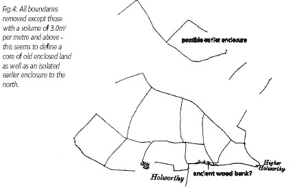
If we now split up Class 3, consigning its lower end (2.6m3- 2.9m3 ) to a class of slighter boundaries and its upper end to a class comprising all boundaries of 3.0m3 per metre and over, we find that almost all the heavy boundaries lie together in the area which retrogressive map analysis would suggest is the early heart of the enclosed land.


Does the analysis of field boundaries contribute anything new, therefore? Well, yes. It not only provides a physical complement to retrogressive map analysis, but can also spring surprises. Holworthy provides two examples. Firstly, to the north of the early core of Holworthy land were formerly three fields (now two) which in the Tithe Apportionment are named West, East and Higher New Ground.West and East have slighter boundaries than those in the core, but Higher New Ground stands apart, having heavy hedge-banks all round (apart from on its northern edge where there is a cornditch). Map analysis might suggest, and now the boundary analysis seems to confirm that this is an earlier enclosure that has been incorporated into the ‘New Ground’, whenever that occurred. Secondly, the class 7 boundaries include one which, on the Tithe Map, is recorded as a narrow strip of woodland. It is in fact a bank, however, measuring almost 5 metres through the base and 2 metres high with stone facing on both sides. It is one of the few which includes mature holly and is the only one with established bluebells. This looks more like a remnant of woodland and may represent an old wood bank remaining from before the development of Holworthy Farm, which is first recorded in 1213. This suggests that the farm may have been created through land clearance in the 12th/13th century.


Finally, on the subject of hedgerow species, people who know of the so-called Hooper rule, in which counting the species is supposed to provide an indication of age, will be interested to learn that the heftiest, apparently oldest boundaries are on the whole more species-rich than the more lightweight, younger examples. But, the species are still relatively few in number comprising at most seven, but including fast growing weed species such as elder, sallow and sycamore. Apart from beech, which has been a popular choice for hedgerow planting since the 18th century, ash is the dominant species, many examples of which appear to be very old, having repeatedly grown out from massive stools. Oak is almost entirely absent.


From the Bottom Up: Restoring the Holworthy Pot - Helena Jaeschke (Newsletter No 7 2004)


From pictures taken and descriptions provided before the pot was removed from the ground, we already had a good idea of the nature of the object. Nevertheless there’s always an intense amount of examination and discovery when an object first arrives at the conservation lab. In this case the object arrived from the excavation boxed in its soil block and protected in a plaster case. Our first move was to invert it, place it on a padded surface and carefully remove soil to reveal the base and assess its condition.


After several thousand years in a wet, acidic environment, the ceramic was very fragile. This is usually the combined effect of the clay having been fired to a rather low temperature and the dissolution of some of the temper used in its manufacture. If the pot had been allowed to dry out, the ceramic could have shrunk and crumbled away. To prevent this, the wet ceramic needed to be consolidated with a resin which provides strength as the water evaporates. The resin must be able to penetrate the ceramic evenly and remain stable, without changing colour, size or strength. For preference it must also be easily removable in future. Fortunately an excellent stable resin is available: Primal WS 24 is a colloidal dispersion of an acrylic resin, which can be diluted with distilled water for application, and which is soluble in acetone when dry. This solution was used on the Barnstaple kiln which was excavated in 1988 and is displayed in the Museum of North Devon.


As the soil was removed from the base, it was possible to see the nature of the surface on which the pot had been placed. Stones were found touching the base and sides, as though it had been laid on a stony surface, possibly in a stone-lined depression. When all the external soil had been removed (and bagged for later sieving) it was possible to see the size and shape of the pot, still upside down (see photo).


The pot was then turned right way up and supported while the soil inside was removed and put in separate bags for later examination. The only evidence of the vessel’s use was a dark ring visible on the outside of the base. Consolidation was continued as each new area was exposed. When all the soil had been removed from the surfaces of the pot and the consolidated ceramic had dried, the individual sherds could be cleaned with swabs of acetone.


Although many of the fragments were in situ when found, they were separated by soil and roots which had to be removed before the pieces could be reattached. The cleaned sherds were joined together using a viscous solution of Paraloid B72, an acrylic copolymer resin. The stray sherds which had been separately removed from the ground were treated the same way, but were carefully numbered to show their original positions. Some joins were found between the sherds, but few could be found to join the actual pot. This was frustrating as these sherds included a fragment of rim and some decorated with diagonal parallel incisions.


Once the main pieces had been joined, some gapfill was necessary to give the pot sufficient strength to withstand handling and display. The edges of the gaps which would be filled were protected with a thin layer of Paraloid B72. The gaps were then filled with Polyfilla, a commercial blend of plaster of Paris with cellulose powder. This was shaped and then painted with powder pigments mixed in a solution of Paraloid B72 in acetone to provide an overall match which can clearly be distinguished from the original. It is hoped that future work may enable more joins to be made and the rest of the pot to be rebuilt.


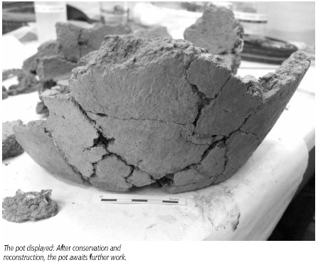
The reconstructed pot is now on display in the Museum of Barnstaple and North Devon.


Summer 2004 Excavations at Holworthy Farm - Terry Green

(Newsletter No 8 2004)


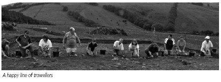
On 19th July 2004, 20 volunteers including members of NDAS and of TAG as well as four students from Exeter University gathered together at Holworthy Farm, Parracombe to begin the season’s excavation on the Holworthy hillslope enclosure. The weather was benign, tented accommodation had been provided by RMB Chivenor, portaloos had arrived, the proposed trenches had been mechanically deturfed and sheep and cattle were kept at bay by a very effective electric fence. This year we were employing a site supervisor in the person of Dr Martin Gillard of English Heritage and Exeter University who freelances as an excavator. Martin brought with him four student volunteers from Exeter, Sam, James, Nick and Flick (Felicity!) who were comfortably accommodated in a barn at Walner Farm. In addition, Martin’s partner Genna had baked a cake which was ceremonially doled out with a (clean) trowel at the first morning teabreak.


Things were off to a good start and in general were to stay that way. Since the 2003 evaluation trenches had turned up evidence of Bronze Age occupation, the plan for 2004 was to open up a larger area so that the pottery and gully feature previously exposed could be seen within a broader context. In addition we wanted to explore the nature of key features of the site highlighted by Ross Dean’s magnetometry 5 survey. This meant open-area excavation as well as trenches, and consequently the Society was into its first full-scale excavation on a potentially very important site. Fortunately we were also blessed with a goodly quantity of enthusiastic volunteers (some 30 in all) from NDAS and from TAG and from the general public. They all deserve our heartfelt thanks for their hard work. In this regard, our thanks go again to Phil and Julie Rawle of Holworthy Farm for permission to dig and to Fred, Sue and Robbie Rawle for permission to access the site across their land.We also wish to thank Phil and Jean Griffiths for providing accommodation for the students and for allowing us to hold our barbecue at Walner Farm at the end of the Open Day. Thanks also go to RMB Chivenor for the loan of tents and of men to put them up.


The Excavation:

Ross Dean had previously been over the site with resistivity and gradiometer surveys and worked up the data into very readable colour-coded plots which enabled us to place our open areas and trenches where we might acquire the most information.


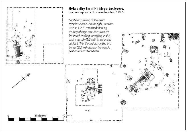
Trench 1 was laid out 12.0m x 1.5m E-W acoss the E enclosure bank. At this point the slight earthwork seemed relatively well preserved so we hoped to get a good idea of its construction.We also wanted to explore a linear feature which the geophysical survey showed curving around the edge of the enclosure at this point.


Trench 2 was an open area laid out 10.0m x 10.0m in the NE quadrant of the enclosure. The purpose of this was to pursue the implications of the Middle Bronze Age pottery vessel and of the length of gulley filled with charcoal and charcoal stained soil found in 2003. This area lay across a slight platform which had been previously identified by earthwork survey and which included possible areas of burning activity identified by the geophysics.


Trench 3 was laid out 12.0m x 1.5m to the NE of Trench 2. Like Trench 1, the purpose here was to explore the linear feature identified by geophysical survey and to ascertain its relationship to the enclosure.


Trench 4 was laid out 4.0m x 4.0m at a distance of 30.0m NW of Trench 2 in an area where geophysical survey had indicated a number of linear features which suggested small rectilinear enclosures, possibly ditched or fenced paddocks or small arable fields. In addition the linear feature to be explored in Trenches 1 and 3 also reached this far and crossed the edge of one of the “enclosures”. The purpose here, therefore, was to examine this junction of features.


The Results:


Trench 1:

After removal of the turf and ploughsoil, a 1.5m – 2.0m wide band of densely packed stone was revealed lying N-S just below the highest point of the enclosure bank. When this was further explored by removal of the stone, it was found that the earthwork had been formed by cutting into the natural slope and revetting the resulting surface with stone. To the E beyond this band of stone lay a random scatter of stone of varying size lying in a restricted, but not coherent band running N-S through the trench. There was the possibility that this might represent the linear feature identified by geophysical survey, but when the area was examined by box-section, nothing identifiable was revealed. There was however an irregular area of disturbance in the SE corner of the trench, but this was thought to represent treeroot disturbance. From the ploughsoil one fragment of possible metal working slag was recovered. This was sent for analysis and was found to contain high levels of copper and arsenic. This raised the tantalising possibility of copper working somewhere nearby, but as the fragment was in the ploughsoil, it could not reliably be tied to the site. However, beneath the compact stonework or revetting a quantity of burnt material was exposed. This was bulksampled and awaits analysis.


Trench 2:

This large area was the most revealing. Removal of the turf and initial mattocking of the ploughsoil revealed a broad and quite dense spread of stone such as had been seen in previous years. This was concentrated towards the NE of the area, becoming less pronounced to the SW. A few sherds of prehistoric pottery were recovered. Successive campaigns of mattocking and trowelling finally removed the overburden of ploughsoil and stone spread, revealing a predominantly orange subsoil with a great deal of embedded stone. The section of gulley revealed in 2003 which had been thought perhaps to represent a drip-gulley, in fact turned out to be part of a shallow trench snaking SE – NW across the site. It was very apparent as a feature filled with dark soil standing out against the orange. Originating towards the SE of the area, it began as a shallow bowl the base of which was apparently baked. The high charcoal content of the fill began at this point and continued for roughly 3.5m. Farther to the NW the trench became more shallow and the fill less dark. Large stones sunk into the fill or lying on top of it were a feature of the trench, as were a number of flint thumbnail scrapers scattered through the fill. At one point very careful excavation revealed what appear to be the carbonised remains of a wooden bowl apparently abandoned in the ashes.


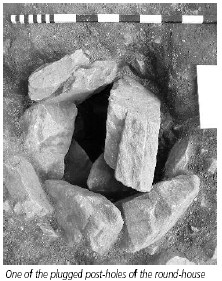
A considerable number of post-hole features were identified. Prominent among these were six, ultimately seven large postholes which were stone-lined and clearly formed two thirds of a circle. It is assumed that these represent the major supporting posts of a roundhouse, which was probably 12m-13m in diameter. The vessel found in 2003 would have been within this structure. Near to its location a quantity of pottery sherds were found mostly in association with a shallow scoop containing charcoal or carbonised wood. Within the area of the apparent roundhouse we also found a small saddle-quern, a clay loomweight and - in a post-hole – a stone tool which may have been used for leather-working. Other post-holes identified may represent divisions within the roundhouse, but more convincingly show a relationship with the charcoal-filled gulley which could pre-date the roundhouse. Other postholes were found sealed beneath what appears to be redeposited material and may date from a period before the enclosure was made. Interestingly a number of the major post-holes were sealed off with a large stone placed in the centre, as if, on abandonment of the site, the posts had been removed and the post-holes plugged or capped.


Trench 3:

Features found in Trench 3 were very similar to those seen in Trench 1, ie. a band of densely packed stone, a band of random stone and a scoop where the hilllside had been dug intoapparently to form a scarp and a platform. As in Trench 1, a box-section was dug to explore beneath the random stone, but no feature resembling a ditch could be identified.


Trench 4:

This 16m2 area was meticulously excavated by Sam Wells, one of the Exeter students. The identified features included a single large posthole in the W corner of the area which was stonelined and ‘capped’ just like those in Trench 2; a spread of random stone like that seen in Trenches 1 and 3; a line of stake-holes running E-W and corresponding in orientation to the edges of the ‘paddocks’ suggested by geophysical survey. There was, however, again no clear sign of the linear feature.


Provisional Conclusions:


- This part of the earthwork was formed by cutting into the natural slope of the ground and drawing material forward to form a platform. The scarp formed by cutting into the ground was revetted with stone. There may have been a palisade or dead-hedge on top of this.

- There may have been a structure on the site before the formation of the earthwork.

- There was a period during which activity on the site involved burning within a trench.

- This activity probably pre-dates the construction of a major roundhouse.

- As the stone lining and capping of the large post-holes were already apparent in the lowest layer of overburden, they probably represent

– in the form of a large round-house - the last phase of activity.

- To have survived intact and in situ, the vessel base found in 2003 must also belong to the most recent phase of activity on the site. It therefore provides broad dating for this phase, ie. Middle Bronze Age, around 1,000 – 1,200 BC.

- There may well have been small paddock-like enclosures associated with the earthwork, but firm conclusions cannot yet be drawn about this.

The single post-hole found “capped” in Trench 4 suggests the possibility of another large structure to the west.


Possible Future Work:


- There is a further area of geophysical interest in the SW quadrant of the enclosure. The interest centres upon a “burning event”. If analysis of soil samples suggests some kind of “industrial” activity, further exploration may be necessary

- The possibility of an entrance to the enclosure on the SE probably needs to be examined.

- The system of “paddocks” invites further investigation.

- The possibility of a structure to the west also invites investigation.

With so much burning activity on the site, we have a lot of charcoal from which to select samples for species identification and Carbon 14 dating. In addition we have numerous bulk samples taken from different contexts which need to be treated in order to extract possible environmental evidence. Treatment means wet sieving and sorting by flotation. This is a wet and probably chilly job, but has the potential to be very rewarding. Physically separating environmental treasures from soil and clay is a job

for volunteers. Any offers? Please contact Alistair (01598 740359)


Higher Holworthy


While we were digging on the hillslope enclosure, Jim Knights took a party of volunteers down to the abandoned site of Higher Holworthy in the valley below. This small settlement was shown as inhabited at the time of the Tithe Survey (1840’s), but was deserted by the time of the 1851 census. In the 1840’s it was a separate holding from Holworthy being occupied by Thomas Dovell. All we see now is an irregular enclosure, a ruined barn and some struggling apple-trees. Jim had previously used the Society’s resistivity meter to conduct a geophysical survey on the site and had come up with what appeared to be traces of a building. As far as we could tell this was in the right position to represent a building shown on the tithe map, but only excavation would prove it. So Jim’s party of volunteers dug test-pits. And lo and behold, they came down on the stump of a wall and the remnants of a slate-flagged floor! There was a certain amount of pottery of late 18th and early 19th century date and the stump of wall had been rendered in lime plaster. So this was a domestic building and very probably the house of Thomas Dovell. This site needs more work which will probably be included in any future excavation at Holworthy Farm.


The following bodies helped NDAS to fund the Holworthy Excavation in 2004:

Council for British Archaeology: £500

Exmoor Trust: £200

North Devon District Council (Community Grants): £684

Royal Archaeological Institute: £1200


The Holworthy Project: Progress and Plans -Terry Green

(Newsletter No 9 2005)


During the winter, examination of material recovered in the excavation at Holworthy Farm in 2004 has thrown up some very gratifying results.


As I indicated in the last report, we were able to recover a considerable amount of charcoal from various contexts which meant that we had organic material which could be Carbon 14 dated. The process is based on the fact that all living things absorb, during their lifetime, the unstable isotope of carbon, carbon 14, from their environment. On death, no more is absorbed and what is present at that point begins to break down to a more stable form of carbon. Carbon 14 decay proceeds at a known rate, so that measurement of the proportion of the isotope remaining in, for example, a lump of charcoal, provides a measure of time elapsed since the wood was cut. It’s not quite so straight forward, as the concentration of Carbon 14 in the environment has varied over time, so that raw dates have to be adjusted or ‘calibrated’. Dates are given as BP ie. Before Present where Present is conventionally 1950.


Four gross samples were selected for examination, one from a deposit of burnt material beneath the stones forming the enclosure bank (108), one from a small scoop which contained pottery sherds and charcoal (215) and one from the gulley or trench which snaked through the roundhouse site and had a charcoal-rich fill (208). These were sent first to Rowena Gale for identification as to species and stage of growth, since short-lived species or sapwood are preferred for dating. Then, with financial support from Exmoor National Park, three selected samples were sent to the Scottish Universities Environmental Research Centre in Glasgow.We had to wait two months for the results, but they were worth waiting for. Sample 108 produced a date of (calibrated) 3360 +/- 50 BP; sample 215 gave a date of (calibrated) 3130 +/- 40 BP; and sample 208 came out at (calibrated) 2990 +/- 60 BP. Carbon 14 dating can be unreliable, and more dates will be needed before we can be fully confident, but on the face of it we have a daterange of about 1,400 BC to 1,000 BC, which places our site in the Middle to Later Bronze Age, as the pottery had already suggested.


We have also been able to make some deductions about the Bronze Age environment of the site. From the identification of the charcoal we can say that oak, hazel and willow (presumably sallow or goat willow) were present in the vicinity. Further clues have been provided by pollen recovered from the fill of the gulley. A ‘tinned’ sample was sent to Heather Tinsley of Bristol University who reported that, although the pollen preservation was poor, she could identify oak, hazel, alder and pine, thus adding to the picture of the Bronze Age tree cover. Among herbaceous species she identified principally dandelion, ribwort plantain, daisy and buttercup suggesting disturbed ground around the site, and heather, grasses and fern suggesting an open, grassland environment. She also found roundworm eggcases, which could have come from pigs, but more likely came from people. Heather also found some cereal pollen, which fits nicely with the most recent discoveries.


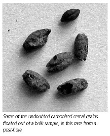
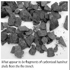
Before we left the site last summer we took bulk samples (40 litres at a time) from a number of contexts. These were to be sorted by flotation in order to extract any organic material, most likely charcoal fragments and other carbonised matter. For this we needed a flotation tank, but did not possess one. Asking around got us nowhere, so we had to provide for ourselves. To this matter David Parker set his mind and manufacturing skills, and, with the generous provision by Alpharma of Whiddon Valley of an empty drum and fine mesh, he succeeded in building a very useful piece of kit (see the accompanying article) with which to treat our samples. At David and Judy Parker’s house in Ilfracombe, a number of Society members spent several cold Saturdays processing the material and ending up with quantities of ‘flot’, the organic matter floated out. During the last couple of months, David has dedicated himself to sorting this material under a binocular microscope (lent by the Museum of Barnstaple and North Devon) and has succeeded in extracting quantities of carbonised seeds, fragments of hazel nut shell and plant fragments. None of these have yet been submitted to a specialist for identification, but among them are undoubted cereal grains, probably barley and emmer wheat, nicely complementing the cereal pollen found by Heather Tinsley. This is the first direct and positive evidence for prehistoric cereal cultivation in the Exmoor area, a first for NDAS!


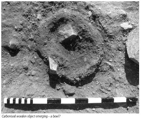
Finally, the carbonised wooden object, which was discovered beside the fire-gulley (see Autumn 2004 7,8) and which was lifted in a soil block, has been excavated from its block and stabilised by Richard Jaeschke. The work was difficult, as much of it is simply charcoal stained soil making a more or less defined shape. Freed from the soil and treated with stabilising chemicals, it is now a pretty unattractive assemblage of bits looking rather like burnt flapjack that has been trodden on! Nevertheless, two fairly large pieces do make sense and do seem to represent part of the body of a wooden bowl or dish.We have yet to get a specialist to look at it.


In July this year we are planning to return to the site, probably for the last time. Starting on 4th July, we intend to excavate between 140 and 200 square metres inside the enclosure. The objectives will be to examine a geophysical ‘hot spot’ identified by Ross Dean, to examine the area below the edge of the house-platform, to look for signs of activity in the centre of the enclosure, to refine dating and add to the environmental evidence.We shall also extend trench 2 of 2004 northwestwards in order to identify further postholes and to try to trace a floor.We have again been successful in securing financial assistance from the Royal Archaeological Institute (£1000), Council for British Archaeology (£500) and North Devon District Council (£500).We are grateful to all of these for their support. Dr Martin Gillard will again be our site supervisor.We already have a good number of volunteers, but anyone else wishing to join in should contact me on 01271 866662.


Finally, at the end of the main excavation period we shall be holding an Open Day at the site for NDAS members and the people of Parracombe. This will be on Sunday 17th July from 10.00 am to 4.00 pm. If you don’t know the site, there will be signs on the approach roads pointing you in the right direction. You will be asked to park on the roadside at SS 689445, from where you have a walk of about 400 metres downhill across grassland. I must point out that we are on private farmland and must, of course, observe all the usual countryside rules about shutting gates.


Members Interest Articles:

The Landscape Context of Holworthy Farm: Chapman Barrows , Hazel Parker ( Newsletter No 9 2005)


An A-Level Student's Thoughts of Holwell Castle, Mary Houldsworth (Newsletter No 9 2005)


Holworthy Farm Excavation, July - August 2005 -Terry Green (Newsletter No 10 2005)


Following the very successful NDAS Holworthy Farm excavation of 2004 – reported in previous newsletters - it was decided early in the year that in 2005 we should follow up by locating the remainder of the apparent roundhouse, exploring some of the interior of the enclosure and examining features highlighted by Ross Dean’s geophysical survey.


Permission and approval were obtained, as before, from Phil and Julie Rawle, Rob Wilson-North; and DEFRA/ESA, while Fred and Sue Rawle once again allowed us to access the site across their land. The excavation was again supervised by Dr Martin Gillard who brought three students from Exeter to supplement the volunteers from NDAS and from TAG.We also had a volunteer from Gloucester who had seen the dig advertised in the Current Archaeology handbook.


Derry Bryant took charge of funding, and was able to raise a total of £2,000 from The Royal Archaeological Institute, the Council for British Archaeology and North Devon District Council.We are grateful to these bodies for their support and must also thank RMB Chivenor once again for the loan of tents. Special mention must be made of Jim Knghts who was a logistical Mary Poppins, always seemingly able to come up with just what was needed!


The excavation was set for the two weeks from 4th to 17th July 2005. There was to be an open day on the final Sunday, 17th July. A barbecue was arranged for volunteers on the middle Saturday at Walner Farm., and we are once again grateful for the hospitality of Phil and Jean Griffiths.


The Excavation:

The site was prepared during the last week of June, when three trenches were pegged out. Trench 1 was laid out 10.0m x 4.0m immediately to the NW of Trench 2 of 2004. Trench 2 was laid out 10.0m x 10.0m in the SW quadrant of the enclosure. Trench 3 was laid out 10.0m x 10.0m on the S side of the enclosure adjacent to Trench 2 of 2004. Ross Dean surveyed the trenches into the overall site plan.


When the excavation began on July 4th the team was initially divided between Trenches 1 and 3, work on Trench 2 not beginning until the ploughsoil had been hand-stripped from Trench 3 and it was ready for first recording. Removal of the ploughsoil in Trench 2 proved more arduous than had been expected and so at the end of the first week it was decided to reduce the area of this trench by 50%. This proved to be a good decision, but inevitably at the end of the fortnight there was still work to do and digging continued intermittently with a reduced team of NDAS members until 17th August. The site was finally closed down on Friday 26th August.


Initial Results:


Trench 1:

The major post-holes located in 2004 were regularly enough spaced to allow us to calculate that there should be another three and to suggest their positions. Gratifyingly, the theory was borne out by excavation, three major post-holes emerging where predicted.We now have the full circumference of a structure which we are interpreting as a roundhouse with a diameter of about 9 metres. In the N corner of the trench a pile of large stones was uncovered, which appear to represent a slump of the surrounding stone bank. About a metre to the SW of this was a band of small flat stones which we have interpreted as a path. Within the “roundhouse” the termination of the 2004 firetrench or gulley was identified. Three of the major post-holes appear to have been recut, one of the earlier cuts containing large amounts of charcoal with a central “pipe” which may represent the charred remains of a post. All of the major postholes, which were cut into a more or less level surface of red/orange subsoil, were stone-lined and apparently blocked after the removal of the post.


Trench 2:

The stated purpose of Trench 2 was to locate and examine the context of a large geophysical anomaly identified in Ross Dean’s magnetometry survey of 2003. The initial plan to excavate 100m2 was trimmed back largely because of the unexpected depth of the ploughsoil in this part of the site. By reducing the area by 50% efforts were concentrated on the SW half of the area. In the deep, relatively humus-rich overburden of ploughsoil, two sherds of Iron Age pottery were found, though there was no further evidence of similar date. When the red/orange subsoil was finally reached, there was an arc of dark material in the S corner of the trench. This turned out to represent a shallow, curving gulley filled with charcoal and charcoal impregnated soil very similar to the fire-trench or gulley that we had seen in Trench 2 of 2004. Excavation of part of the fill revealed a deposit of pottery (some 80 sherds from 7x5cm down to 5x5mm), clearly of a similar fabric to the pottery vessel found in 2003, but with good incised chevron decoration (Plate 1). In the side of the gulley were five large post-holes, two of which appeared to be re-cuts. It appears that the cutting of the gulley may have truncated previously existing post-holes. Within the arc of the curving gulley the subsoil rose to the beginnings of a platform. Beyond the gulley to the north were further post-holes on a similar curved alignment, and on a further parallel arc was a shallow groove similar to a groove feature seen in Trench 2 of 2004. To the NW of the gulley was an arc of stake-holes. A number of the post-holes were D-shaped or roughly triangular suggesting the use of split logs. At the point where Ross Dean had confirmed the location of his geomagnetic anomaly was a post-hole surrounded by stake-holes. The density of features in this trench was all towards the S corner and there is clearly more to be discovered in this direction.


Trench 3:

This trench, the purpose of which was to see what might be happening in the centre of the enclosure, turned out to be relatively devoid of features, but presented some puzzles. There were a number of holes which might have been post-holes, but nothing that showed any discernible pattern. The centre of the area was characterised by an irregular jumble of stone, rather like we had seen in Trench 4 of 2004. Here a band of pale grey material presented a mystery. This light, gritty material, sometimes with flecks of charcoal in it, may have been an artifact, but it so far defies identification. The same material was also seen concentrated in other parts of the trench as well as in Trench 2. In order to try to understand this confusing area, a section was dug across it revealing a soft, gingery soil which, when excavated appeared to be the fill of a ditch. However, the fill showed none of the normal characteristics of a ditch-fill, and when the feature was pursued, it terminated quickly. This may be a geological feature.


Around 50 large and small soil samples were taken, most of them containing organic matter which we hope will provide additional dating and/or environmental evidence. To date the examination of the “flot” resulting from flotation has identified a substantial number of cereal grains together with fragments of chaff which suggests processing on site and probably the growing of grain nearby. Identification of other organic remains awaits specialist attention. There is a lot more work to done on the samples. Anyone wishing to volunteer their assistance, please phone David Parker on 01271 865311.


We may conclude at this point that we have identified this hillslope enclosure as a Middle Bronze Age settlement surrounded by a substantial stone bank within which there was at least one major building. Cereal crops were grown nearby. The settlement was abandoned around 1000 BC. The features of Trench 2 offer a tantalising glimpse of activity and it is tempting to pursue the evidence in the direction of the enclosing bank, in the shelter of which most activity on the site appears to be concentrated. For the present however, it is necessary to consolidate what has been achieved.


Holworthy Farm Update Terry Green

(Newsletter No 11 2006)


After four seasons of excavation at Holworthy Farm we are at the point where we either continue and turn it into a long-term project, collecting more and more data, which in the end gives us at best a partial picture of the birth, life and death of a single settlement; or we draw breath, assemble the data that we have and publish. Obviously there has been debate about this and the consensus is that the long term commitment would add little in the way of understanding, so for the present there will be no further digging at Holworthy Farm. At this point we are pretty confident about the date range of the site, we have environmental information and we are able to discuss function.


At present all of the Holworthy pottery has been marked up and has been to Henrietta Quinnell so that she can estimate the work involved in writing a report. The single 
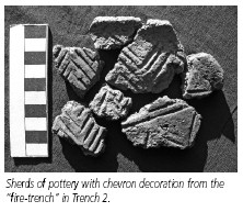
mass of sherds that came from our second “fire-trench” in 2005 has gone to conservators Richard and Helena Jaeschke to be stuck together. David Parker has completed the wet-sieving of the bulk samples taken in 2005 and has recovered quantities of carbonised organic matter, principally wood charcoal and a quantity of seeds and cereal grains – over 1,700 in all. Selected samples of the wood charcoal have been sent to Rowena Gale for species identification, and from among these, five samples plus a number of charred cereal grains have been sent to the Scottish Universities Environmental Research Centre (SUERC) for radiocarbon dating. Anne and Martin Plummer have agreed to write a report on the flints from the site and Sue Watts has agreed to report on the saddle-quern that we found in 2004. Not yet scheduled are the plant macro-fossils (seeds, plant fragments), the “wooden bowl” found in 2004, the loom-weights and an odd stone tool ( a sliver of fine-grained sandstone with a honed edge and one smooth face) that came from a post-hole.


Meanwhile all the context details have been assembled on a data-base, and a start has been made on converting site drawings into digital form.


As indicated above, since the last newsletter, the wet-sieving (flotation) has been completed and organic materials have been isolated. A most pleasing discovery was a substantial quantity of carbonised grain in one post-hole. Substantial is a relative term here – we have 3.9 gm or a small eggcupful – but nevertheless it is important, since the charred grain from Holworthy is the first direct evidence of prehistoric cereal cultivation in North Devon or Exmoor. Why there should be this deposit of burnt grain in a post-hole is a question that needs thinking about, especially as this was all the organic matter in this particular hole, while the neighbouring and inter-cutting post-hole contained a very large quantity of oak charcoal.


Furthermore the grain was concealed beneath a flat stone in the base of the hole. As for wood, identified species include oak, hazel, willow, hawthorn, ash, birch and alder. The wooden bowl or platter (?) excavated in 2004 was of oak. Among the 21 charcoal samples that we have had identified, oak and hazel are by far the most frequently occurring, as one might expect, but ash occurs only once. This is interesting when you consider that ash is a very common tree in the local landscape today and that it makes very good firewood. I have recently discussed this with Dr Judith Cannell, an expert on woodland archaeology, who suggests that ash flourishes in open conditions such as hedgerows, which were probably not a feature of the local Bronze Age landscape.


With the financial support of Exmoor National Park, the samples for radiocarbon dating were sent to Glasgow in February. The results, which have just come back, help to tighten the date range for the features of the site, currently homing in on 1300 - 1400 BC, ie. Middle Bronze Age, as was suggested by the pottery that was unearthed in 2003. In fact a fragment of hazel charcoal found immediately beneath the 2003 pot is dated at around 1400 BC, as is charcoal found in association with the mass of pottery found in 2005. A dated deposit found beneath the stone bank makes it probable that the enclosure was built about 1600 BC, and since the 2003 pot must have been left when the site was abandoned, it seems we can narrow the period of occupation down to about 200 years.


For the purposes of writing up and interpreting the site, we need to be able to place it in both a broad regional setting and in a local context where funerary monuments such as Chapman Barrows are a major feature, but nearby settlement remains on South Common are possibly more meaningful in terms of landscape development. For the purpose of such interpretation, we need to return to the Parracombe Project which got somewhat sidelined when Holworthy came along, but which offers a way to assess the landscape as a whole.